2) 「欝陵島図形」 - "Takeshima in the Korean official map" by Funasugi Rikinobu (舩杉力修)
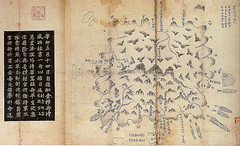
This map describes the entire Ulleundo and is currently owned by Kyujangkak of Korean study center, Seoul National University. It was made by 朴錫昌, who was the official inspector to Ulleundo in 1711. The stone monument that 朴錫昌 built in 1711 still remains, and has been exhibited in the hometown material pavilion of Ulleundo. It is said that there was a sign of "備辺司" on this map. "備辺司" was the organization that had jurisdiction over the border security at a Choson dynasty, and later, its function was expanded, and strengthened back, and it conferred all the domestic general administration like politics, economy, diplomacy, and the culture, etc. to say nothing of military affairs to be decided. Thus, since this map was made by Choson official commander who were dispatched to clear the illegal squatters from the island, based on his actual survey on Ulleundo, with a official sign of "備辺司" which was the decision making organization at a Choson dynasty, it is safe to say that this map is a official map for Choson dynasty.
Although it is not a modern ordnance map, it has been understood that it is a map where the port, the river, and the village, etc. were drawn almost accurately when you compare the result of the actual field investigation. The most noticeable fact on this map is that there is an island next to Ulleundo on the east side. According to the analysis of Mr. Gerry Bevers, an American resident in Korea, there was a description with "So-called Usando and the field of 海長 bamboo"on this small island. He assumed that "海長 bamboo" was Japanese "女竹", and concluded that this small island (Usando) was Jukdo which locate to the 2km east to Ulleundo, not present Takeshima/Dokdo on which it is impossible to grow the bamboo in any rate. Present Takeshima is located in the southeast from about 90km of Ulleundo.
Therefore, in a so-called official government manufactured map of the Choson dynasty, it is clear that "Usando" is not the present Takeshima/Dokdo on which South Korea insists to be it is.
By the way, there was an counterargument that since there are about hundreds of maps on which Usando was drawn and it is too exaggerated to conclude that it is not Dokdo from only several maps among all. (Takeshima / Dokdo Net News No.6). I wrote an objection to this opinion in the closeout report, saying that "If you insist that there are about hundreds of maps on which Usando was drawn, you have certain obligation to present which maps draw Usando as the today's Takeshima/Dokdo." However, no clear rebuttal is presented by South Korean side yet.
*Related articles ;
1711 - Bak Chang-seok's (朴昌錫) Map of Ulleungdo (「鬱陵島圖形」)
1711 - Ulleungdo Inspector Bak Chang-seok's (朴昌錫) 1711 Inscription
Lies, Half-truths, and Dokdo Video, Maps 7 : 鬱陵島圖形(ca. 1711)
「朝鮮側作製の官製地図にみる竹島(Takeshima in the Korean official map)」 by associate professor Funasugi Rikinobu (舩杉力修) of Shimane University.
Translated by Kaneganese.
Courtesy of Web Takeshima Research Center.
Gerry and pacifist,
ReplyDeleteCould you please check my translation when you have time? Thank you.